
Day 4, Sat. May 12: Up early and enjoyed one cup of coffee in our room. Joe announced that before we do any sightseeing we need to get gas and since there is no gas sold inside the parks; Sequoia nor the adjoining Kings Canyon N.P. per the brochure, he began Googling service stations near the parks. He of course had to remind me that as we drove through the last town north on 65 toward Sequoia, he had said “we ought to stop and fill up. There may not be anyplace to buy gas inside the park.” I said “We have half a tank. Surely there will be a gas station or two just outside the park.” I mistakenly had this image of a touristy town much closer to the park, and since we had no map of California and the navigation system in the rental car only parsed out information regarding our route on a need-to-know basis, with no hints at what was ahead, we were driving blind. Joe found a Chevron station on 180 almost to Fresno going out the north-west gate of Sequoia, which would put us in the vicinity for the places we wanted to visit. So that was our plan, hoping we’d be ok on gas with our quarter tank and a big oversized Tahoe.
We had breakfast at the Lodge and I stopped at the desk to ask where the closest place to get gas was. She circled Stony Creek Village on the park map, half the distance up 180. She explained that it may not be opened yet for the season and that it was not in either National Park, but just over the border in the Sequoia National Forest, a technicality. So we headed north, got gas, which we had to pool our cash to pay for as they did not have their credit card system up yet, (it was almost $5 per gal) and then on to see the Sequoias.
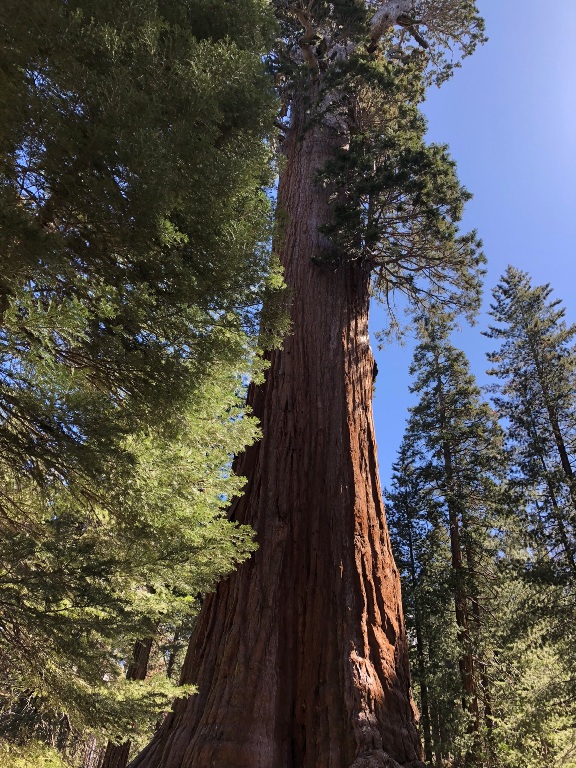
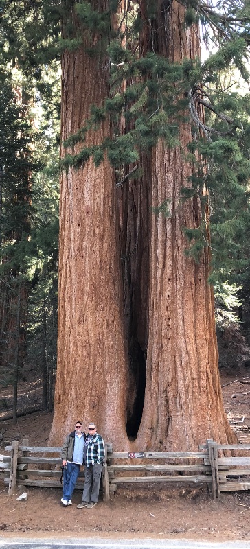
We continued north towards Kings Canyon Visitor Center and Grant Grove Village, stopping at numerous pull-offs along the road to take in the massive trees. At Grant Grove we parked in the lot and trekked along a path to see more awesome mammoth Sequoias, all of them behind a low wooden fence with “Keep Out” signs. We behaved and did not jump the barrier in order to get closer to the trees for our pictures, even though without the proximity of a human, the photos do not capture the enormous size of these monsters. And of course our little camera lenses and cell phones could not take in the extreme height of The General Grant, the second largest tree in the world. It is a 3,000 year old behemoth that is 270 feet tall and 107 feet circumference at its base. The largest tree (they are measured by volume) is The General Sherman which is further south in the park. The Sherman stands 275 feet tall, and is over 36 feet in diameter at the base, 102.6 feet circumference. Sequoia trunks remain wide high up. Sixty feet above the base, the Sherman Tree is 17.5 feet in diameter.
The temperature began to warm up, in the 60s. But the warmth didn’t last. As we left the Sequoias behind and began to drive east on Kings Canyon Road in California’s Sierra Nevada Mountains, the altitude increased and the air became cooler. At 7,000+ feet we stopped at almost every pull-off to take in the panoramic views, soaring rock buttresses and snow capped blue mountains in the distance. Deep in the canyon, if you were brave enough to stare down, you could see the King River, a green ribbon snaking along the boulders. The white sections we knew were the rapids. The road began to descend, or was it the river that was ascending to meet us, but suddenly around a bend, we were driving along with the rolling white water racing downhill on our left. At one point we crossed a bridge and there was Grizzly Falls cascading down to join the river. Again our meager photos do nothing to capture the beauty and wildness of this land. At this point we were deep in Kings Canyon, granite walls and mountains hemming us in. Eventually the river calmed down and at one bathroom stop we walked across a field to a cool green pool. The water was still moving, but not frothing. I stepped down into the wet sandy bank adding my shoe tracks to the small animal prints that had not been washed away yet.
We passed Zumwalt Meadow and came to Roads End, the place where Kings Canyon Road comes to an end at a parking lot with a picnic and camping area. Signs inform hikers that they need to have a permit to leave this paved area on foot to follow the trial that joins the Pacific Crest Trail, which follows the crest of the western mountain ranges. The Ranger told us back at the Visitor’s Center that hikers can actually hike the PCT all the way north to Canada or south to Mexico. I learned a lot about this rugged big sister of the Appalachian Trail when I read the book Wild by Cheryl Strayed.
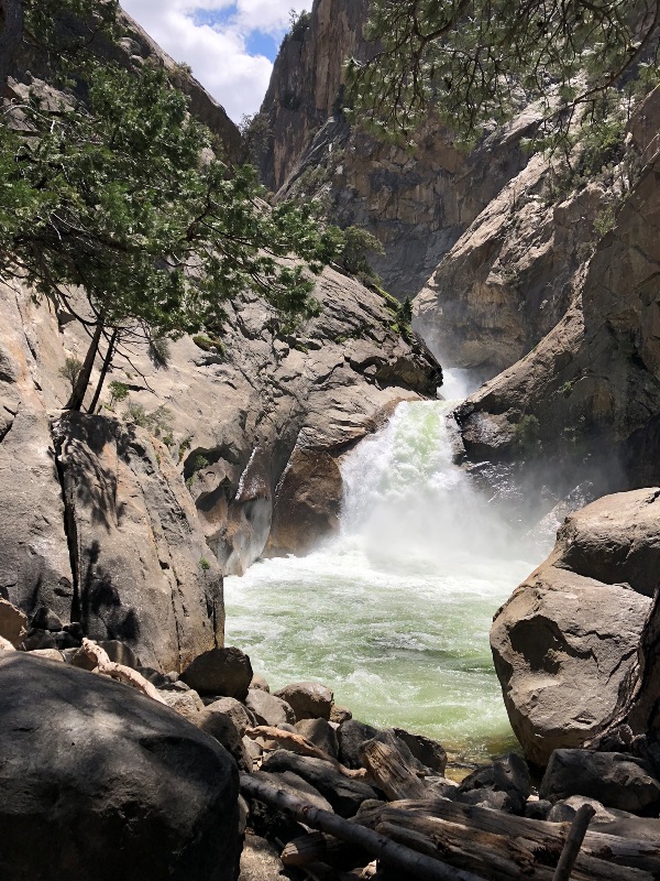
Since none of us were planning to hike to Canada, nor could we if we wanted to, we had to drive back the way we came, west on Kings Canyon Road. We pulled off at Roaring Falls and walked the quarter mile or so up a paved path to get a good view of the cascading water. Nothing compares to the rush you experience when you are in close proximity to thousands of cubic feet of water falling and roaring and rushing past you. There were many others waiting behind us to step up to the barrier to experience the falls, so we were unable to spend any meaningful time in that place. So me and Joe headed down a dirt path that weaved around and between boulders and trees toward the pool below the falling water. We got close to the edge and sat on a rock to take a selfie. Ron came down behind us with Rita following him.
When Rita got to the water Joe began to tease her saying, don’t fall in, cause you’ll ruin my vacation. We’ll have to call someone to fish you out and maybe even take you to the hospital. This inane banter continued while we traversed back to the car, how inconvenienced the rest of us would be if one of us had a calamity, falling into a canyon, or being swept away by surging white water.
As we began to drive uphill, around and up and along hair pin switchbacks the river receded and again became the green snake it started out as. When we got to Hume Lake turn off, we headed south, instead of going back toward General Grant Grove, where we began. All day we had seen many dead trees. Some standing, but not green. Some standing and blackened by fire, and some that had been cut and left lying on the forest floor. But as we drove down Ten Mile Road towards Generals Highway there seemed to be even more dead trees, logs lying like toothpicks spilled from a box, with live trees standing here and there among them. Obviously the trees were cut, most likely because they were dead and would fall. When I got home I Googled this phenomenon to understand what happened and why. I learned that most of the dead trees were Ponderosa Pines ravaged by the beetle blitzkrieg. The U.S. Forest Service estimates that since 2010, more than 102 million drought-stressed and beetle-ravaged trees have died across 7.7 million acres of California forest. More than half of those died since 2015. Thank God for diversity. The forest is populated with not only Ponderosa Pine and the giant Sequoias, but there are Jeffrey Pines, Red Firs, Douglas Firs, White Firs and the infamous Lodgepole Pines.
We were back in our room by 4:30 pm, we rested and freshened up then headed to the Lodge for dinner, where we talked about our proposed drive the next day. With road closures due to snow, we all agreed that we did not want to even try to drive to Yosemite, nor did we want to cancel our reservations at Tamarack Lodge in Mammoth Lakes and lose half the cost, which was over $200. So we decided we’d go to Tamarack and enjoy a full day of rest and relaxation. Even if it is cold and rainy, we reasoned, the lodge is a Ski resort and has awesome facilities where we can relax in front of a fire place. Once we made the decision, we felt relief.
Read Previous Post May 11th, California Crows
Read Next Post May 13, California Driving

