
Day 5, Sun. May 13: Left around 7:00 am, 34 degrees this morning with frost on cars. We headed west on CA-180 toward Fresno. Soon there was confusion with the navigation system. She wants us to go south on CA-63 toward Bakersfield. Google and my iPhone show almost 100 fewer miles going north on CA-99 out of Fresno. We made it to Fresno before 8, it was in the 60s. We drove past rolling hills of brown and yellow grass spotted with grazing cattle. Heading north on CA-59 the land flattened out into dry scrub grassland. We drove through many small towns and orchards along both sides of the road. By 10 am it was 68 outside the car. We had trouble finding a good breakfast place, Rita’s phone found a Denny’s and we got off the exit, following the voice from her LG phone’s nav app only to realize that it wanted us to do a U-ey, and get back on the expressway to head south to the Denny’s we had passed back in Fresno. So we ended up eating at Jack N Box; coffee, breakfast sandwiches and greasy potato patties. Once we were back on CA-99 we passed a Denny’s at the very next exit.
We reverted to using Ron’s cell phone – after he had finally got his GPS to respond. He had been trying for what seemed like forever, talking into his phone, saying over and over again “Driving directions to Tamarack Lodge”. Rita said he was like Jody Foster in the movie Contact trying to get a response from aliens in other galaxies. But our trust in technology soon eroded when the lady on Ron’s LG phone had us turn down county roads, off CA-59 in some crazy attempt to cut off miles at the expense of our sanity, time and comfort. It felt like we were riding a buckboard down a rutted dirt road. I had moved to the back seat by then, to allow Ron to be the Narragater – a word we (me, Joe, Ron and Rita) had coined in 1999 while on a road trip to Canada. It is a combination of navigator and narrator. So I was not much help. My iPhone 6 had been useless this whole trip, so I got Joe’s iPhone 8 and pulled up his map app and expanded it out and out, until I had a good view of most of Northern California. I pulled out paper and pen from my purse and wrote out my version of a trip-tik: 132 to 49 north, 120 west, 108 east, 395 south, at which point I took over as the backseat driver, telling Joe where to turn.
When we stopped in Coulterville, a small town, with a western-hippie-California-touristy vibe, where we bought some drinks and snacks. And I finally picked up the much coveted California map at the visitor’s center. We headed out of town on 49, only to be thwarted within 10 minutes by a road closure. Luckily we were able to talk to one of the construction guys who gave me road by road instructions on how to get to 108. I jotted down the roads as he rattled them off, names and numbers. We had to turn around and head back to town to get to the alternate route. But suddenly Joe was asking where his cell phone was and everything came to a stop as I began riffling through my purse and book bag looking for it. I even tried calling his number to hear the familiar space-age-spooky ringtone to no avail. We headed back to Coulterville to pick up Greeley Road per Road Construction guy and stopped at the visitor center, where I went in to inquire whether I had left an iPhone on the counter. Not there. Back in the car, I did a second check of my bag and there it was. We did not hear it ring because Joe had the sound turned all the way down. Thus the assumption that the phone was not in the car with us. We were all tired and irritable so it didn’t take much to set us off, but we all settled down for the rest of the journey. Driving north on Greeley Road was very nice. The land was rolling farmland, much like Kentucky with small cattle farms and orchards. Joe said if he never drove another curvy snaky road the rest of his life it would be too soon.
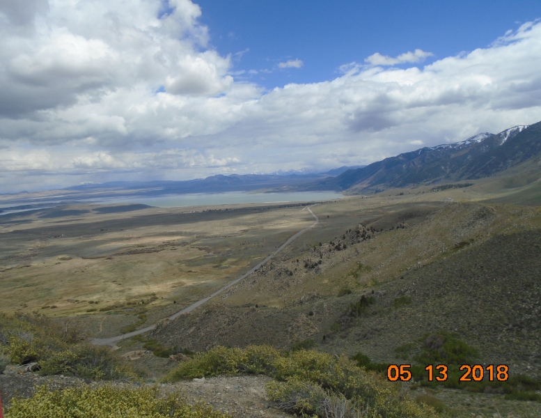
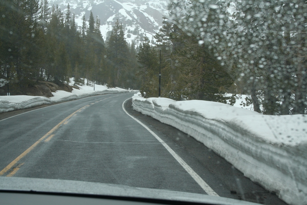
We made good time once we got on 108. The elevation increased with each mile as we headed east into the Sierra Nevada’s. There was snow piled high on both sides of the road. By the time we got to 9,000 feet we all had headaches from the altitude. The temperature was dropping also; 34 and icy rain coming down. The combination of mountains and weather was both exhilarating and frightening. After we went through Sonora Pass at 9,254 feet we began our descent on the other side of Yosemite.
South on 395 was a piece of cake. Four lanes and no mountains to traverse. Around 4:30 pm we arrived in Mammoth Lakes and checked into Tamarack Lodge. Almost 10 hours on the road. This is a ski resort town. Some dirty snow was still piled in places. Lots of condos and touristy things. Once we arrived at the lodge we could see the cabins nestled on the side of the foothills, mountains on all sides, a small lake in front. We are truly enchanted by this resort nestled in the mountains. We each have a one bedroom cabin with a fireplace and full kitchen. From our front window you can see the other cabins and the lake on a backdrop of the snow covered mountains. The cabin is simple and comfy looking. Couldn’t wait to get settled in for the night, but first we headed to town for a dinner of pizza and beer, then on to the grocery to buy something easy for tomorrow’s dinner. Back in the cabin Joe and I enjoyed sitting with our feet up, sipping Sauvignon Blanc gazing at the dancing flames of the gas log fireplace. We really needed this. No TV. No cell phones. But we do have WiFi. Maybe.
Read Previous Post May 12th, Sequoia & Kings Canyon
Read Next Post May 14th, Mountain Lakes

